Named one of the 25 best hikes in the world, Shenandoah National Park’s Old Rag is just 20 miles from downtown Culpeper.
by Lenny Richardson, Intake Specialist and outdoor enthusiast, Burnett & Williams
This past March, Outside Magazine published “The 25 Best Hikes in the World Right Now,” and our very own Old Rag Mountain, which is part of Shenandoah National Park, made the list! We’re in good company, too, alongside other spectacular sites like Everest Base Camp in Nepal, Lares Trek in Peru, Fisherfields Round in Scotland, and the Kalalau Trail in Hawaii.
Sometimes we need to be reminded that we live in one of the most amazing places in the world.
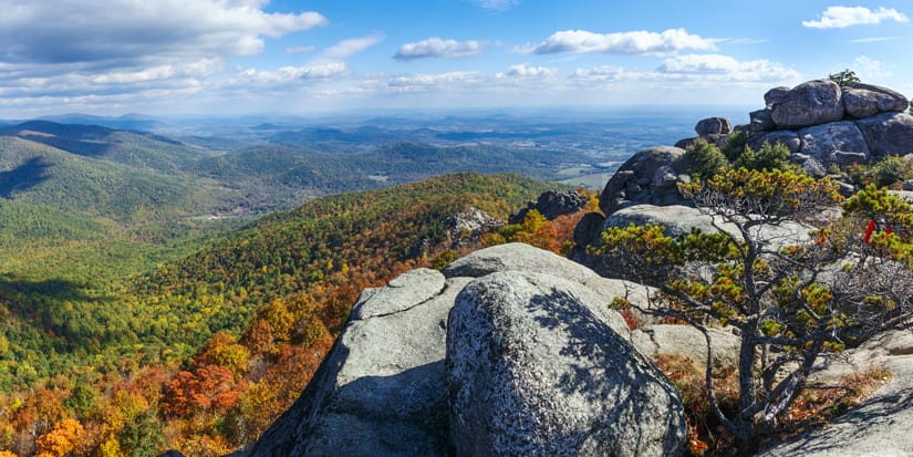
While Old Rag certainly isn’t as famous as Everest, it is an absolutely spectacular hike. Old Rag’s summit, at 3,284 feet, vaunts amazing views of the expansive Shenandoah National Park, and getting there is equally awe-inspiring. As Outside Magazine describes it, “After a two-mile switchback ascent through thick deciduous forest, the trail scrambles around granite boulders, up a natural staircase of quartz and feldspar, and tops out at numerous false summits before reaching the true summit and the best view of the sprawling, 200,000-acre Shenandoah National Park.”

Old Rag, Old Rocks
Virginia’s Old Rag Mountain is named for ‘old rag granite,’ the form of very hard and resistant crystallized magma that underlies the elevation. This old rag granite was created over a billion years ago — that makes Old Rag about 900 million years OLDER than the West’s Rocky Mountains! The United States Geological Survey provides a great downloadable guide for hikers, where you can get an overview of Old Rag’s tectonic history, as well as a useful trail map marked by fascinating sight notes, such as where to see massive boulders that move imperceptibly downhill, and where observant hikers might spot gems like blue quartz and red garnet.

When to Go
Anytime is a good time to hike Old Rag, as long as you keep in mind the particular challenges that come with each season, and any limitations you might have as a hiker. Before you set out, make sure you check the National Park website for trail closures — anything from flooding to fragile vegetation can influence which trails are open to the hiking public.
If you don’t mind being on the trail with a good number of other hikers, a springtime hike will treat you to as many as 850 species of flowering plants. A summertime outing will find you immersed in lush foliage and canopy, while in the fall the colors of the changing leaves can be spectacular. Trails tend to be less crowded during the winter months, particularly mid-week; this is also a great time for geology buffs to hit the trail because the terrain is more visible when the trees are bare.

Don’t Just Jump in the Car, This Hike Isn’t for Everyone
The National Parks Service’s Shenandoah website says Old Rag is the most popular, challenging, and dangerous hike of its over 500 miles of trails. To help make your hike both enjoyable and safe, they’ve dedicated a page to preparations you should make for your day on the mountain. Among their suggestions for ensuring that your hike is a successful and fun one are being sure to carry plenty of water with you; wearing sturdy and comfortable hiking boots; being certain that every member of your group is fit enough to complete the rather strenuous hike; and planning for a good 7-8 hours to complete the entire hike. While you’re at the NPS site, you can also download a trail map.
Directions
When you’re all prepped and ready to go, set the navigation in your car or on your phone to Lower Old Rag Parking Lot & Fee Station. From Winchester, the drive is about 60 miles on I-81 South and I-66 East. If you’re coming from Culpeper, it’s only about 20 miles to the Old Rag parking lot if you take the Sperryville Pike. And from Charlottesville, the drive is about 45 miles along US-29 North.
Tell Us About Your Favorite Hike
If you go, we’d love to hear about your Old Rag experience! Or tell us about another inspiring hike you’ve taken. Send us a note at contact@burnettwilliams.com, or write to us on our website here.